- Blog
-
by Pete Green
Part 1 Theory
Is it still relevant for today?
RYA Yachtmaster Ocean is the RYA’s highest shore-based theory qualification. With multiple sources of GPS on a boat, why is it still relevant to learn an instrument based on 800-year-old technology and look up data from volumes of paper tables?
For centuries sailors have navigated oceans by fixing a position with a sextant observing the sun, moon, stars, and planets. Today, it is not only a fascinating art, but an essential alternative to GPS and electronic plotters when redundancy and reliability are essential for crossing oceans.
Electronics and the power to supply them can and do fail. Salt water is an enemy and there is plenty of it in the middle of an ocean. You may have redundancy with multiple GPS devices but that doesn’t help if none of them are receiving because of jamming, interference, or atmospheric conditions.
If you know the sun rises in the East and the North star is in the North, you already have some astronavigation knowledge. With the reliability of just paper & pencil and a simple mechanical instrument, you can find out where you are on the planet to within a few nautical miles.
Many sailors will embark on learning celestial navigation for their own satisfaction, knowledge and dare I say pleasure. For others, it is a required vocational qualification and revered standard. Halcyon Yachts employs yacht delivery skippers with a minimum Yachtmaster Ocean qualification so to become a delivery skipper it is a qualification you rightly need to gain.
RYA Syllabus and Pre-Requisites
To get the RYA Yachtmaster Ocean Certificate of Competence you need to be a Yachtmaster Offshore, do a qualifying passage, take astro navigation sights and pass an exam.
The qualifying passage must be over 600 nm (and over 96 hours) where 200 nm are more than 50 nm from land or charted objects and completed within the last 10 years. You must evidence taking a full part in the planning and preparation and had a solo watch. The astro navigation requirements are a sun or noon sight transfer position fix and a celestial compass check, not necessarily on the qualifying passage.
The exam is an oral and written test. The oral test covers all aspects of ocean passage making in a yacht, including planning, navigation, meteorology, crew management and yacht preparation, maintenance, and repairs. Candidates must send the examiner an account of the qualifying passage and evidence of taking sights 48 hours in advance.
The good news is if you pass the Yachtmaster Ocean Theory you don’t need to take the written part of the exam and that is the subject of this blog.
Ocean Theory Courses
The two main routes to learning RYA Ocean theory are classroom and online. Courses are typically a weeklong or online with 40 hours estimated study and cost from under £300.
There are many providers of online theory courses, I used www.skippersonline.net which has a modern interactive interface, worked on all my devices, and allowed learning at my own pace. The exam can be done at home if just for personal development but if commercial endorsement is required then the exam must be invigilated by any RYA Instructor using only the student tables and sight proforma templates provided.
What is Astronavigation?
I won’t pretend to explain astronavigation in a blog but can give a flavour of the content and principles. It was only on the last course module covering the North Star (Polaris) that I had the eureka moment and things clicked into place, so I’ll start there to give a layman’s guide to the theory.
The North Star is always in the North so it’s bearing (or Azimuth) is always north. It is almost directly above the North Pole (89° 16’ N) so is in the same place every day! If you were stood at the North Pole, it would be right above you, on your Zenith (an imaginary point directly above a location). If you were close to the equator, it would be very low in the sky, almost on the horizon (90° from your Zenith). Some basic trigonometry then proves your latitude (in the Northern hemisphere) is always equal to the height of the North Star above the horizon.
Let’s say you measure Polaris as having an altitude of 50°, then your latitude is also 50°. This doesn’t tell you where you are, but it does confirm your latitude as one position line. At 50° latitude you could be anywhere west of the Isles of Scilly, East of New Foundland or in the North Pacific but hopefully you’ll be able to narrow that down!
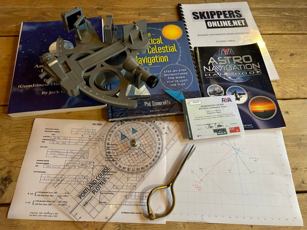
The principal is then the same as Day Skipper, getting position lines from more than one source (or the same one transferred over time) then plotting where they cross to get a fix. If you get stuck an excellent additional resource is “The Practical Guide to Celestial Navigation” by Phil Somerville. A copy of which is now on the bookshelf of my boat along with some generic proformas and plotting sheets.
Using a Sextant
The shore-based course teaches how to use a sextant but unless you construct an artificial horizon with a bowl of water you’ll have to wait until on passage to try it out.
It is called sextant because its arc is 1/6th of a circle i.e., 60° but it can measure angles up to 120° using a principle of double reflection. The mechanics are to adjust the sextant arm whilst using telescope, mirrors, and shades to bring the celestial body being measured down (or up) to meet the horizon. You should take a series of readings over a minute or two and average them on a chart ignoring outliers to select a reading you will use.
There are then some adjustments to make including “index error” of the instrument, “dip” from curvature of the earth based on your height of eye and various potential altitude corrections such as the semi-diameter of the celestial body, terrestrial refraction, and parallax.
The final corrected result is the True Altitude (Ho). After looking up in tables what the Calculated Altitude (Hc) should be, the difference is then how far away you are on the earth’s surface from an assumed position giving a position line.
We have produced a series of videos that will also help you to learn and master the sextant:
What Sights Can You Take?
To take a sight both horizon and celestial body must be visible, and you need more than one sight for a fix. One method is to take a sun sight, update your approximate position to be on the sun sight position line then apply dead reckoning and take another sun sight as a running fix. This is known as a “sun run sun”, one of the position lines could be a simple latitude derived from a “noon sight”, the sun at local noon (Meridian Passage).
Other options may be available at twilight if the moon and planets are visible along with the horizon. Possibly easier are stars. Of the 2 x 10²³ stars in the visible universe and the 4,500 visible by eye, the positions of 57 most useful stars are recorded in non-perpetual volumes valid for a few years (epoch). To simplify things, altitude and azimuth are given relative to a hypothetic point in the sky (Aries) and don’t require sight reduction calculations.
Meridians and Hour Angles
The Earth is mapped by an imaginary grid of latitude and longitude lines. Latitudes run from 0° at the equator to 90° North and South at the poles. Latitudes are measured in degrees of declination, the angle north or south from the celestial equator. The declination of the sun changes seasonally from the tropic of Cancer 23.4°N (northern hemisphere summer) to the tropic of Capricorn 23.4°S (northern hemisphere winter) as the Earth orbits the sun.
Longitudes are vertical meridians like segments of a chocolate orange running East to West from a prime meridian. Greenwich meridian was voted by 22 countries as the global prime meridian in 1884, although France continued using the Paris meridian until 1911.
Each minute of longitude is a nautical mile at the surface, and hence a degree of longitude is 60nm. In Astro navigation, the longitude position of a heavenly body is measured by Greenwich Hour Angle (GHA) running west from 0° Greenwich Meridian. A longitude of 90° East is thus GHA 270°. The earth rotates every 24 hours, hence 15° per hour or 1° every 4 minutes. As you sail west, noon becomes later.
A Local Hour Angle (LHA) is the angle from your position to the heavenly body and is GHA minus your longitude if west or GHA plus longitude if East. For stars we use a Siderial Hour Angle (SHA) which is the angle between GHA and “Aries”, a hypothetical point in where the sun crosses the celestial equator on the northern spring equinox.
Because the earth spins, to measure any hour angle from celestial bodies you need to know the exact time to the second. The British Parliament passed the Longitude Act in 1714 with a reward of £20,000 (£3.35m in 2023) for solving longitude at sea to within half a degree, eventually won by John Harrison, carpenter and clockmaker who invented the marine chronometer.
Today a cheap digital watch set to GMT will work but may still need correcting as can vary 15-30 seconds per month. In preparation for taking sights, I set three cheap digital watches to the exact time using www.time.is and plan to measure their variation before leaving.
5 Top Tips for Tables
The theory course is full of opportunities to make errors and it can be hugely frustrating having to trace your steps back to the start to try and find the error. Here are some things that tripped me up when referring to the student tables provided:
-
Read the headings for columns and rows very carefully. Column headings can change down the page for blocks of rows (e.g., data for stars) so may it not be the heading at the very top.
-
Check carefully whether data is positive or negative. In some cases, refer to prior rows where this is given.
-
The typeface is old and sometimes tricky to read. Look at the trend for the previous and subsequent periods as a check.
-
Note how data trends to check if you should add or subtract. Is declination for example increasing or decreasing and apply that when using data for corrections.
-
Get used to mental arithmetic in base 60. A simple technique for subtraction is to re-write degrees and minutes with one less degree (e.g., convert 90° 00’ to 89° 60’) to make base 60 subtraction easier.
Proformas and Spreadsheets
For each type of sight (sun, planets, moon, and stars) there is a separate proforma to use in calculations. I made my own spreadsheet versions as calculators for backup and for notes to remind me of the process. Other versions can be found online with various formats, but these worked for me. They are free to download and whilst I believe they are stress tested they come with no warranty and are no substitute for paper and pen!
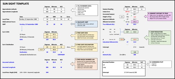
Example Sun Sight from Excel Templates – Free Download: Astro Nav Templates
More than just Astro
The theory course is not just astronavigation but includes ocean passage planning, communications, global meteorology and how to check your compass. You may find some parts of passage planning common sense and communications is a rapidly changing subject with advances in satellite internet access. You will however need to dust off your Yachtmaster Offshore meteorology and learn about great circle passages, tropical cyclones, trade winds and ocean currents.
Taking the Exam
The exam is two hours long and you will have some sight reductions, plotting and non-astro navigation questions to answer. For an online course, you’ll need a computer, internet connection and venue with any RYA instructor to invigilate.
Take your time to get settled with coloured pens, 2b pencils, plotter, dividers, student tables and some plain A4 paper. Unlike previous theory courses, plotting is not done on charts but on self-made plotting sheets. You can buy generic plotting sheets, but the course will teach you to make your own based on your approximate latitude to get the relative scale right. The student tables are all based on 50° latitude so I made a plotting sheet for that and (with permission) printed half a dozen off to take into the exam which I was very glad of.
You start the exam in your own time, then move forwards or backwards through the questions to complete as you wish. When the time is up, you’ll be asked to upload scans or photos of your work, a camera phone is useful for this.
Getting the Result
Once uploaded, a system message said results would come through in 2 or 3 working days’ time, however I had an email that evening confirming I had passed along with detailed feedback and model answers. Shortly after, an electronic copy of the certification was emailed with a hard copy in the post.
If you are a member of Halcyon Yachts, then please update us with any new RYA qualifications by email to team@halcyonyachts.com. To become a yacht delivery skipper with Halcyon Yachts you will need RYA Yachtmaster Ocean Commercially Endorsed, at least 10,000 NM experience as skipper, a trial sail, good references, and skippers’ third-party liability insurance.
Our continued outstanding reputation is based on the skills and dedication of our skippers. We have the highest standards in the industry, as such our Skippers are qualified to RYA Yachtmaster Ocean as a minimum.
Overall, I thoroughly enjoyed the course and have learned a new skill that will be used. For nearly a decade I carried a Mark 25 Davis sextant on my 32ft yacht with an equally unopened astronavigation book. Not much use without the sight reduction tables, proformas, plotting sheets and knowledge to use it. Our next long passage I’m going to enjoy impressing the crew by plotting a few sights to update our dead reckoning with a fix. We will of course still use GPS, but the Mark 25 will no longer be hidden at the bottom of a locker.
Author: Richard Payne, Sales and Operations Manager – Halcyon Yachts.

With highly qualified and experienced crew, Halcyon Yachts Ltd offers a dedicated international yacht delivery service. For more information or to see details of their recent deliveries please visit: https://halcyonyachts.com/