- Blog
-
by Pete Green
“Plan for the tide and manage the wind” is the phrase often given for coastal sailing, but blue water ocean passages can be very different. Planning on a global scale when and where to sail is still based on meteorological trends as old as the Earth. Unless you carry a lot of fuel, global passages are planned around prevailing winds and ocean currents rather than tides. Even container ships follow ocean currents for speed and economy.
Trade Winds
Trade winds are the companions of sailors. They are reliable and consistent prevailing easterlies blowing from east to west either side of the doldrums. Warm air rises near the equator flowing towards the poles then cools and descends at the subtropics around 25° latitude returning towards the equator. Known as a Hadley Cell, this global thermal circulation is deflected west by the Coriolis effect as the Earth spins. From roughly 30° to 60° latitudes we get an opposite westerly wind, such as the prevailing wind experienced on the south coast of the UK.
Ocean Surface Currents
Surface currents can be caused by differences in temperature, density, and salinity as well as prevailing winds and the rotation of the earth. Convection currents generally move warm water towards the polar regions and cold water towards the tropics.
In the North Atlantic, the Canary Current brings colder water from Europe down the west coast of North Africa and the Gulf Stream moves warmer water from the Gulf of Mexico up the eastern US coastline. The Gulf Stream is typically 100km wide and travels up to three knots (which the author experienced first-hand a week or so ago from writing this blog).

These combined forces of prevailing winds and ocean currents guide sailors where to sail but we still need to consider when to go.
It is possible for some vessels to go most places at any time within reason but as with all sailing everything is a compromise. Skippers would likely wish to avoid high latitudes in winter and areas where the risk of tropical storms is high whilst maximising available time for a passage or to enjoy the destination.
Hurricanes & Typhoons
Strong tropical cyclones are called Hurricanes in the Atlantic or northeastern Pacific and Typhoons in the northwestern Pacific. The planet experiences 80-90 named tropical cyclones per year of which over half are hurricane force of 120 km/hr for more. These storms are generally initiated where the sea is warmer than 26.5° at 5° to 30° latitudes. The warm moist air rises causing low surface pressure that creates wind and rotates from the Earth spinning. In the Atlantic, tropical depressions can form off West Africa and build to hurricanes as the trade winds carry then west before dissipating over land.
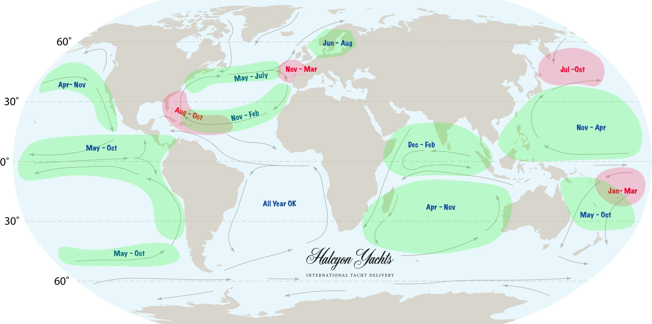
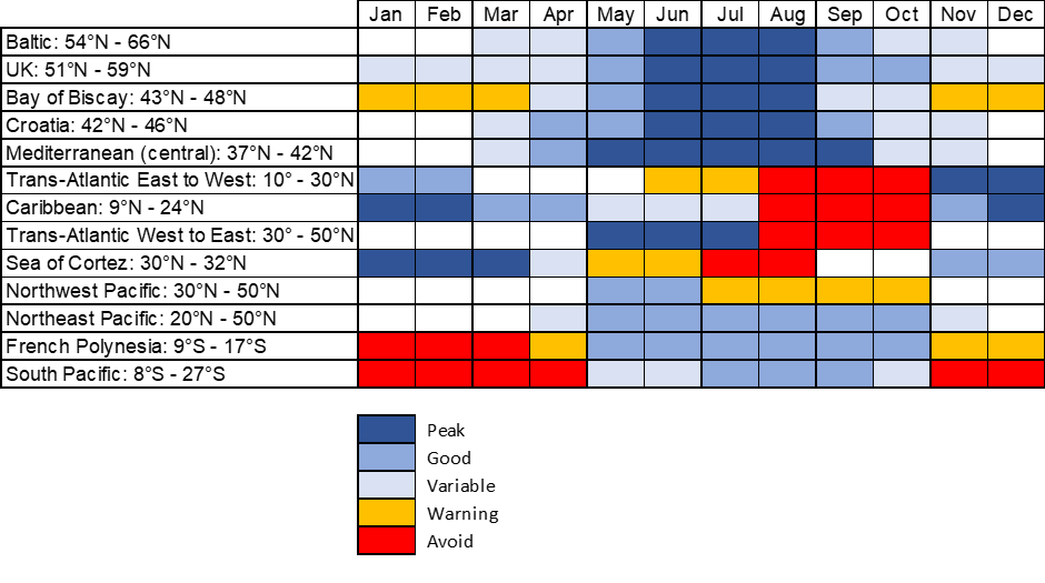
Average sailing seasons are mapped in the following guide. In the UK for example it is possible to sail all year round but the further north and into the Baltics peak seasons can limited to June to August with cold water and long days. During summer you can experience up to 24 hours of sunlight above the Arctic Circle.
For worldwide cruising there are few resources better than Jimmy Cornell’s World Cruising Routes now in its 9th edition, www.cornellsailing.com. This blog will focus on a yacht delivery business’s first hand experience of the North Atlantic and Pacific Ocean crossings.
Part 1 – North Atlantic
The North Atlantic provides a sailing circuit with prevailing wind and current going south from the Canaries, west from Cape Verde to the Caribbean then north via the Gulf Stream and east from Nova Scotia to Europe. Many vessels go to the Caribbean for owners to enjoy the winter season then back across to Europe early spring to avoid tropical storms.
Starting from the UK and northern Europe, the first obstacle heading south is the Bay of Biscay. Whilst a crossing is possible anytime in larger vessels, some hull insurance policies may restrict sailing across Biscay between October and March. 48° North may mark the start of Biscay, which would allow you to sail no further south than the treacherous Raz de Sein. Many vessels thus transcend from the UK to the Canaries in September ready to cross the Atlantic in November.
The optimum time to sail across the Atlantic (East to West) is November to February when trade winds have established, and temperatures are moderate. Latter months offer more reliable winds; however, many boat owners wish to arrive before Christmas and maximise cruising time available hence November is popular, certainly for the “ARC”.
The World Cruising Club (WCC)
The World Cruising Club (WCC) was formed by Jimmy Cornell following the inaugural Atlantic Rally for Cruisers (ARC) in 1986. Andrew Bishop took over in 1998. The WCC organises many ARC rallies in the Atlantic, Pacific, Baltic, and European waters and runs the popular cruising forum noonsite.com.
The ARC
The WCC organises the ARC which attracts 1,200 sailors on over 200 boats every year to sail the 2,700 from Gran Canaria to Saint Lucia. The organisers define it as social cruising with an element of fun competition. Engines are permitted and corrected handicap times are available.
The traditional start is in November and a separate ARC January offers more constant trade winds on the rhumb line to complete it in 18-21 days on a 40-foot cruising yacht.
The ARC+ is a variant on the ARC that goes via Cape Verde to maximise the trade winds and finishes in Grenada. The first leg from Gran Canaria to São Vicente is 850nm estimated to take 5-7 days for a 40-footer. The second leg runs across the Atlantic at 16-17º latitude and is 2,150nm estimated at 12-16 days.
Once in the Caribbean, peak season runs from December to February with good sailing in November, March and April. Unless risking an uninsured berth during summer or heading further South or into the Pacific, boats continuing the Atlantic circuit will start returning north then east from April.
It is common for hull insurance policies to have exclusions 10° to 37° North from 1st June to avoid tropical storms. The peak risk is August to October when the sea temperature is highest. Historical data from the National Hurricane Centre in Miami shows a marked peak in September for Atlantic Hurricanes and Tropical Storms and relatively lower risk in the surrounding months of June, July and November but still possible. The US National Oceanic & Atmospheric Administration (NOAA) predicts above-normal risk in 2024 due to sea temperatures and El Nino.
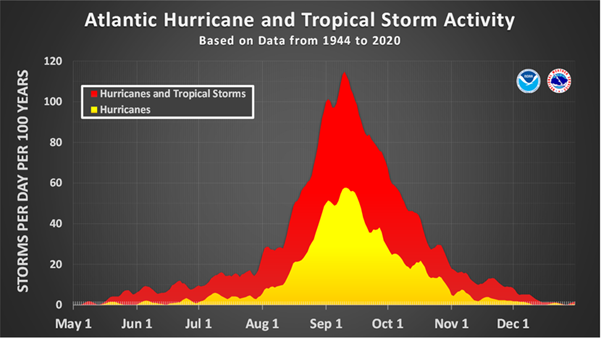
Image Source: NOAA, U.S. Department of Commerce
A popular route back to Europe is north towards Bermuda before heading East to the Azores. The WCC runs ARC Europe which leaves St Maarten or the US East Coast in May on a route via Bermuda and the Azores to Lagos in Portugal. The three legs total just under 3,500nm with prize giving at the end of June.
All skippers should research, and plan based using the latest available information relative to their vessel and communications equipment on board. If lucky enough to have some communications equipment on board such as Starlink, satellite phone or GPS tracker with messaging you can get weather updates or small GRIB files to spot and track depressions forming. The risk then decreases for June & July however tropical cyclones are 500 km wide and can move forward 16-24 km/h on average and up to 65km/h so if unable to outrun at least ensure you can be in the “less dangerous” quadrant!
Part 2 – The Pacific
The Pacific Ocean is huge. Panama to Australia is 8,000 nm compared to the 2,000 nm Atlantic crossing from Cape Verde to Barbados. It is a similar circuit to the Atlantic but bigger. The most common route from the Panama Canal heading west is nicknames the “Milk Run” via the Galápagos Islands then 3,000nm to the Marquesas and French Polynesia.
The optimum window to leave Panama runs from February to June. Leaving early gives more time before needed to avoid the cyclone season at the western edge of the Pacific however leaving later promises more consistent trade winds. The cyclone area to avoid is south of 10° and west of 140° from November to April.
Routes east are more difficult and complicated. From Indonesia you would head north of Japan to latitudes of 50° before tracking east to Canada. From New Zealand the route via Tuamotu goes NNW past Hawaii before east to Canada. The alternative is south round the Cape of Good Hope as included in the “World ARC”.
The World ARC leaves St Lucia in January and crosses the Pacific via the Panama Canal to Australia. This 8,000nm cruise takes in Galapagos, Marquesas, Tahiti, and Fiji finishing at the Great Barrier Reef in August. The second part is 11,500nm and leaves Darwin in September and continues west via Mauritius, round the Cape of Good Hope to Brazil, the Windward Islands and finishes in Saint Luca in April.
Whichever route you take will require much research and planning. www.noonsite.com is a useful resource offering free membership as well as basic and premium monthly subscriptions for $2.99 and $6.99. The paid membership allows downloads, access to a map for anchorages and more than 3 country “formalities” per month (arrival details).
Whether you would like some help sailing to the Caribbean for a season, need a professional skipper and crew to bring her back to Europe or have found your ideal purchase the other side of the Pacific, Halcyon Yachts can assist.

With highly qualified and experienced crew, Halcyon Yachts Ltd offers a dedicated international yacht delivery service. For more information or to see details of their recent deliveries please visit: https://halcyonyachts.com/